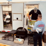
SPRINGFIELD, Virginia – The National Geospatial-Intelligence Agency is providing geospatial intelligence support to the combined search and rescue efforts in the aftermath of Hurricane Ian from the headquarters of Florida Task Force 1 in Fort Myers, Florida.
Esri Partners with Federal Government and State of California to Tackle Climate Change, Improve Resilience
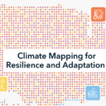
Map-Based Dashboards Help Communities Assess Exposure to Climate Hazards and Conservation Opportunities
US Postal Service Celebrates NASA’s Webb Telescope With New Stamp

The U.S. Postal Service will issue a stamp highlighting NASA’s James Webb Space Telescope on Sept. 8, 2022. U.S. Postal Service Art Director Derry Noyes designed the stamp using existing art by James Vaughan and an image provided by NASA and the Space Telescope Science Institute. Credits: U.S. Postal Service
Apple Introduces iPhone 14 and iPhone 14 Plus

A new, larger 6.7-inch size joins the popular 6.1-inch design, featuring a new dual-camera system, Crash Detection, a smartphone industry-first safety service with Emergency SOS via satellite, and the best battery life on iPhone
NOAA still expects above-normal Atlantic hurricane season

Preparedness is key during the peak months of hurricane season
Preliminary Agenda Announced for 2022 UAS Summit & Expo

Produced by UAS Magazine, the UAS Summit will provide attendees with a comprehensive overview of the current state of the unmanned aircraft systems industry.
Esri Launches Indoor Positioning System for Facility Wayfinding

ArcGIS IPS Indoor Positioning Software Improves Operational Efficiency and Safety
Esri Releases ArcGIS GeoAnalytics Engine, Enabling Comprehensive Spatial Analysis for Big Data
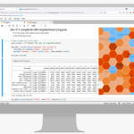
New Product Streamlines and Optimizes Spatial Analysis for Big Data Workflows
NOAA predicts above-normal 2022 Atlantic Hurricane Season

Ongoing La Niña, above-average Atlantic temperatures set the stage for busy season ahead
UP42 and Airbus Launch Copernicus Masters Challenge for Sustainable Urban Planning

Calling on all developers and researchers to leverage remote sensing to accelerate the UN Sustainable Development Goals