USGIF announces new multi-year scholarships from AWS, Leidos, and GDIT
ICSC Unveils ICSC MARKETPLACES IQ

Comprehensive business tool provides members with a centralized hub for property search, industry and demographic analysis, and site selection
World Economic Forum Selects Terradepth for Ocean Data Challenge to Advance Marine Knowledge and Promote Blue Economy

Eleven Ocean Innovators Chosen Worldwide
Esri Releases New App to Easily View and Analyze Global Land-Cover Changes
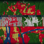
Sentinel-2 Land Cover Explorer Makes Visualizing and Understanding Satellite Data More Accessible for Decision-Makers
HERE Workspace: The low-code platform tool for map creation now comes with machine learning from AWS

Amsterdam and Las Vegas, AWS re:Invent 2022 – HERE Technologies today announced that HERE Workspace is expanding to give enterprises more ways to integrate spatial intelligence into their business operations, supply chains and fleets.
Presagis Launches Cloud-Based VELOCITY 5D Digital Twin Production Platform – Fast, Scalable, Realistic

Montreal, Canada, November 15, 2022 — Presagis, a global leader in 3D advanced modelling and simulation software, has officially launched its VELOCITY 5D (V5D) cloud-based platform that quickly and automatically converts massive volumes of 2D geospatial data into high-fidelity 3D digital twins. V5D leverages artificial intelligence and game engine technology to run complex visualization and simulation scenarios […]
Terradepth Announces Commercial Launch of Absolute Ocean Marine Data Management Platform

Secure Data Management, Visualization, Collaboration
Customers Line Up for New Beans Route ‘Find My Scanner’ Feature
Geospatial data creation company introduces a new way to help delivery drivers track their asset scanners
ESA and GAF AG continue offering free-of-charge access to DSMs, high-resolution and medium-resolution data via the Third Party Mission Scheme
Munich/Neustrelitz, Germany, XX October 2022: ESA and GAF AG will continue to provide free-of-charge access to Digital Surface Models (DSMs), high-resolution (HR) and medium-resolution (MR) data for scientific users. In September 2022 they extended their agreement under ESA’s Third-Party Missions (TPM) Programme regarding the provision of IRS data and DSMs until the end of 2024 […]
Hexagon to update aerial data of eight U.S. states at six-inch resolution in 2023 for the HxGN Content Program
(Norcross, Georgia, USA, 3 November 2022) Hexagon’s Geosystems division announced today that the HxGN Content Program will refresh aerial data of eight U.S. states at 6-inch (15-centimeter) resolution for the 2023 collection season, including Texas, Washington, Florida, South Carolina, Virginia, Maine, Montana and Idaho. Additional states may be added as the season progresses.